Introduction India, with its vast coastline and strategic location in South Asia, is home to several islands spread across the Bay of Bengal and the Arabian Sea. These islands not only have ecological and geographical importance but also play a critical role in India’s security, culture, and biodiversity. Indian Islands Andaman & Nicobar
Table of Contents
- Indian Islands
- Andaman and Nicobar Islands
- Lakshadweep Islands
Indian Islands
- The major islands groups of India are Andaman and Nicobar Archipelago (A chain of islands similar in origin) in Bay of Bengal and Lakshadweep islands in Arabian Sea.

- Andaman and Nicobar Islands were formed due to collision between Indian Plate and Burma Minor Plate [part of Eurasian Plate][Similar to formation of Himalayas].
- Andaman and Nicobar Islands are southward extension of Arakan Yoma range [Myanmar][Arakan Yoma in itself is an extension of Purvanchal Hills].
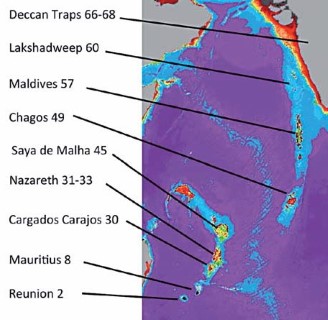
- Lakshadweep Islands are coral islands. These islands are a part Reunion Hotspot volcanism. [Both these concepts are explained in previous posts]
- Other than these two groups there are islands in Indo-Gangetic Delta [they are more a part of delta than islands] and between India and Sri Lanka [Remnants of Adams Bridge; formed due to submergence].
Andaman and Nicobar Islands
- The Andaman and Nicobar Islands consist of 572 islands, islets, and rocks. Out of these, around 38 are inhabited. These islands are located in the Bay of Bengal, extending from 6°45’N to 13°45’N latitude and 92°10’E to 94°15’E longitude. This archipelago stretches over 590 km.
- Origin & Geology: Formed due to the collision between the Indian Plate and Burma Minor Plate, these islands are considered an extension of the Arakan Yoma range of Myanmar. They consist of tertiary sandstone, limestone, and shale, with a volcanic foundation.
- Divisions: The Andaman Islands are divided into North, Middle, and South Andaman. Duncan Passage separates Little Andaman from South Andaman. The Ten Degree Channel separates the Andaman group from the Nicobar group.
- Capital: Port Blair is the capital city, located in South Andaman.
- Notable Islands: Among the Nicobar group, Great Nicobar is the largest and southernmost island, while Car Nicobar is the northernmost.
- Volcanic Activity: The Barren Island is India’s only active volcano, and Narcondam Island is a dormant volcano. Both are located north of Port Blair.
- Biodiversity: Many islands are covered in thick tropical forests, with coral reefs along the shores. The highest peak is Saddle Peak (737 m) in North Andaman.
- Strategic Importance: The proposed Great Nicobar transshipment port, military installations, and surveillance systems make this group geopolitically critical.
Lakshadweep Islands
The Lakshadweep Islands comprise 36 islands, islets, and atolls located in the Arabian Sea, 200 to 500 km southwest of Kerala.
Origin & Structure: These are coral atolls formed due to Reunion Hotspot volcanism. Unlike the mountainous Andaman-Nicobar, Lakshadweep islands are flat and rarely exceed 5 meters above sea level.
Divisions:
Amindivi Islands (northernmost): Includes Amini, Kadmat, Chetlat.
Laccadive Islands (central): Includes Kavaratti (capital), Kalpeni, Androth.
Minicoy Island (southernmost): Known for its unique culture and language.
Ecological Significance: The islands are surrounded by fringing reefs, and many have white sand beaches and rich marine biodiversity.
Challenges: The low elevation makes these islands extremely vulnerable to sea-level rise, posing a long-term threat to their survival.
Recent Development: The Indian government has been boosting infrastructure with INS Jatayu (a naval base) and proposals to improve connectivity and tourism.

New Moore Island
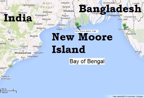
- New Moore Island is a small, uninhabited sandbar located in the Bay of Bengal, near the mouth of the Hariabhanga River in the Sundarbans delta region.
- Formation: It emerged after the 1970 Bhola cyclone and frequently submerged due to coastal changes and rising sea levels.
- Territorial Dispute: Despite being uninhabited, India and Bangladesh both claimed the island, primarily due to potential natural gas and oil reserves. The dispute was linked to broader maritime boundary disagreements.
- Current Status: Satellite imagery and research show that the island no longer exists permanently above sea level. It remains a subject of study in marine and geopolitical discussions.
Other Island Types in India
- River Islands: India is also home to notable river islands, the most famous being Majuli in Assam—one of the largest inhabited river islands in the world.
- Adams Bridge: Between India and Sri Lanka lies a chain of limestone shoals, believed to be remnants of a submerged land connection known as Adam’s Bridge or Ram Setu.
Territorial disputes in the South China Sea
Geography of India An Introduction For UPSC IAS
The deal is dead. Seychelles Assumption Island And Indian Army Base


